This tourist circuit is a must, and a very attractive place for bikers. Lakes, mountains and forests are the ideal company to feel part of an overwhelming nature.
Duration: More than a day
Distance: 110 kms
Recommendations: Take bottles of water, a warm jacket, energy food, and do not forget changing the pace of your walk whenever you have difficult stretches. Ask for information about which are the best places for the different stops or stages.
Enabled: Summer, Autumn, Spring
Description tour: 7 Lakes
The cycling starts
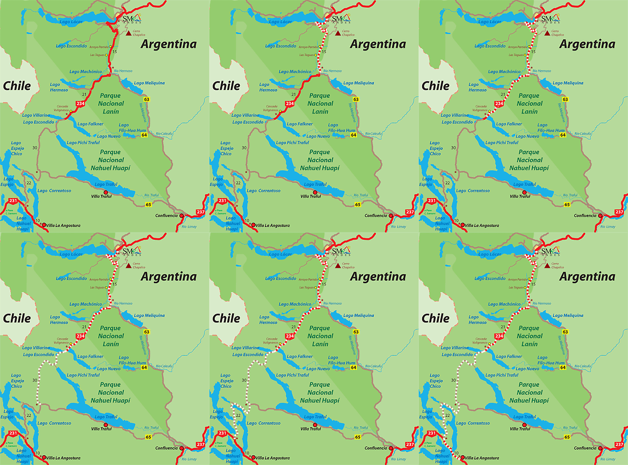
The circuit starts taking the National Road Nº 40 (234 before) "the Seven Lakes Road," between a native forest and populations of the Mapuche Community Curruhuinca.
Going straight up, along the paved road, you will find the Pil-Pil viewpoint, an ideal place to rest for a while and enjoy a spectacular panoramic view.
500 metres from here you will see the junction of the Provincial Road Nº 19 which goes towards Chapelco Mountain.
The way makes a pause. Further on, the Arroyo Partido (Divided Stream) and its viewpoint let you understand a geographical curiosity of great importance in boundary matters between Argentina and Chile.
A sharp and prolonged way down leads to Hermoso River, where you will be able to see several hills that exceed the 1,800 metres high. At that point, on the left starts the Provincial Road Nº 63 that goes towards Paso Córdoba and Confluencia.
Then we continue the way down the road, there are two short slopes and the viewpoint of the Machónico Lake.
Seven km further, on the right side of the road, you will find the detour that leads after about 2 km to Hermoso Lake. The area offers wild and organized camping options, accommodation and a supply shop. The option is to stay for the night here, but if your legs do not just say no, the suggestion is to continue riding until the next lake.
Falkner and Villarino Lakes
About 9 km along the road you will see Vullignanco Cascade (which means lizard in Mapuche language), it has about 20 metres high and it is located in Nahuel Huapi National Park. Almost 2 km from there and a total of 48 km from the starting point, to the left you will reach Falkner Lake, with a wide sandy beach and a camping area. On your right you will see Villarino Lake, where the pavement finishes in its viewpoint.
The place is ideal to spend the first night. Two km from here there is Lake Escondido. From there, a permanent decline of about 8 Km will lead to the Park Ranger's House in Pichi Traful. A short detour of 2 km will let you enjoy the North arm of Traful Lake, one of the good options to spend the night.
From here on, a long and tiring climb without pauses begins, until reaching the detour on the left, the Provincial Road Nº 65, which goes to Villa Traful, located on the edge of Traful Lake.
The last effort
Continuing along to Villa la Angostura, there are 32 final kilometres, going past Correntoso, Espejo Chico (2 km on the right) and Espejo Lakes, with the Park Ranger's House and a free camping area.
A final slope will lead to the junction with the National Road Nº 231 that will let you take, on the right, Cardenal Samoré (Puyehue) International Pass.
On your left, being able to enjoy the amazing Nahuel Huapi Lake, a continuous but not steep way up will demand you the last effort to reach Villa la Angostura.

Office: Secretaría de Turismo - Av. San Martín y Juan Manuel de Rosas
Opening hours: 7:00hs a 14:00hs
Phone: 02972-425500
 Back to: Sports and Adventure
 Visit also:
Trekking,
Meetings and Events,
Horseback_Riding,
Mountaineering
